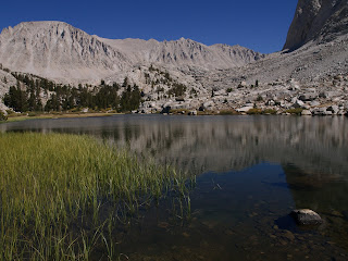

A six o'clock departure for the summit. To ward off the cold I was bundled up in my mid-weight thermal top, both gloved hands shoved deep inside the pockets of my rain jacket, hood fully extended to cover my ears and as much of my face as possible, slightly hunched over to preserve the body's warmth. The trail gradually rises, passing a couple of lovely alpine lakes before it quite literally hits a wall. The switchbacks start here and for the next mile and a half you find your way zig-zagging to the crest. Just think of it as the ultimate StairMaster workout. You can drop your pack at the crest junction, but I chose not to. What else was I going to carry my food and water in? Besides, I'd left everything but the essentials back in camp, so my pack was really light. The remainder of the summitting process is walking along the right side of the dividing ridge, which has a couple of nasty places where you definitely don't want to fall, and then swinging in a half loop over to the west and back up to the east. The last time I tried this I was on a day hike with my sister, Loana. We were coming up the eastern side from Lone Pine and started the climb at one in the morning. About half way up the switchbacks, I started feeling weak and nauseous. Tried to fight through it, but altitude sickness had me in its grip. Felt real bad for my sister because she was feeling strong, but refused to go to the top alone. This time round, no problems. Shortly after 11:00 I was standing on top of the highest mountain in the contiguous United States, wishing that my sister could be here with me to enjoy the 360 degree panoramic view. Again, I celebrated by stuffing my face full of candy. I deserved it. I'd burned a lot of calories getting up there. I hung around for half an hour enjoying the dizzying heights and the view of the myriad peaks of the Sierra Nevada. Also saw other people celebrate as they reached the top, some of them singly, the others in pairs or small groups. I passed even more on the way back down to the junction. All the JMTers who come from Crabtree Meadow to summit Whitney continue on the trail leading down to Lone Pine. I, as a PCT thru-hiker, had to return to Crabtree and keep heading south to Kennedy Meadows. Going down was a lot faster than going up, but the switchbacks were jarring and a true test for both knees and ankles. Back in Crabtree, I took another forty minutes to rest and relax (mostly with my feet dangling in the waters of the nearby creek), before breaking camp. I didn't need to go to far, just enough to make a little progress on the trail. When I crossed Rock Creek and saw the campsites there, I knew I'd found my place for the night.
Where I'd Come From
Mt. Whitney
Timberline Lake
23 Miles

No comments:
Post a Comment